Earth Science Unit Study
Week 8: We created our own contour maps.Contour maps are valuable navigating tools for hikers and naturalists. The wavy lines indicate elevation and are always closed loops. The video How to Read a Map & Contour Lines explains several unique features of contour maps. For example, when the wavy lines point towards a peak, that is an indication there is a low path such as a stream bed running down the mountain.
After watching the video, we completed a project from Janice VanCleave's A+ Projects in Earth Science: Winning Experiments for Science Fairs and Extra Credit
First an irregular shaped mountain was created.
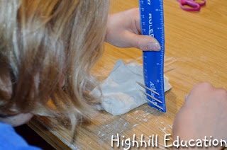
Additional toothpicks were added such that four lines running down the mountain were stuck with toothpicks at every centimeter of height.
Next the mountains were placed on a piece of paper and a pencil was used to trace around the base. In addition, the locations of the four columns of toothpicks were marked on the paper.
Wrapping the floss around the mountain and pulling the ends together just under to bottom row of toothpicks the bottom layer was sliced off the mountain. Then the mountain was then lifted from the paper, the bottom layer placed on the table and the mountain placed back on top of the paper ensuring that the toothpick paper marks were lined up. Then the next contour line was drawn and the process was repeated until the top of the mountain was reached.
Looking at the above contour map, several features of the mountain can be seen. There are two peaks indicated by the two small circles. The slope on the left side is gradual which is indicated by the larger spaces between the contour lines. There is a valley between the two peaks indicated by the contour lines pointing toward the peaks.
This visual, hands-on activity created a much deeper understanding of reading contour maps.
Please visit our Science Page for more hands-on Earth Science activities and don't miss theses great blog hops.

* I did not receive any compensation for this recommendation. I'm just a homeschooling mom who has found many products that I like. If you're interested in the products I recommend on this blog I want to make it easy for you to find them.
** I am an Amazon associate and receive a small portion of the sales on orders made after clicking in from this site, which I promptly spend on homeschooling books and supplies for my children.


These look fantastic! What a great geography activity!
ReplyDeleteWhat a great project - cutting off each layer is very creative! I need to save this one for future use.
ReplyDelete